
Lake Tahoe is a dream for hikers and other outdoor enthusiasts. Out of the entire Sierra Nevada mountains, Lake Tahoe has always been a spectacularly heavenly region. Lake Tahoe is home to some of the US’s best skiing, water sports, and hiking. North America’s largest mountain lake is home to hundreds of miles of hiking trails including on national forest and state park land. Residents and visitors alike would have trouble seeing it all! If you plan on visiting and hiking Lake Tahoe, see 10 of our favorite trails in the northern and southern regions.
Hiking for beginners – Be prepared, and know your limits
Hiking is a popular pastime for a reason – it’s more accessible than other outdoor sports, it brings you out into the most beautiful parts of the outdoors, and it’s especially healthy for anyone who can do it. No matter where you plan to hike, there are basic principles you should be prepared to follow so you can be best prepared to hit the trailhead. Here are some of my own suggestions before you embark on Lake Tahoe:
Pack extra water
Personally, I always carry a 32 oz water bottle with me to stay hydrated. A good rule of thumb is a half liter of water per hour of hiking, but you may need more depending on the weather. Some trails have water sources, but you should always filter your water if you choose to draw from them.
Always bring snacks
Small, handheld snacks are my first choice for hikes. Whether it is a granola bar or a small bag of carrots, you should bring something nutrient-packed that leaves you feeling more energized.
Take breaks
Don’t be in a rush to get to the end of your trail! Hiking can be taxing on your body, and a quick 5-minute break can be a great chance to hydrate, stretch, and have a quick snack.
Leave no trace
Anything that you take with you on a hike should also be leaving with you when you reach your car to head home. Any trash that you leave adds up, especially in a place like Lake Tahoe which gets millions of visitors every year. Don’t add to the problem; in fact, bonus points if you pick up trash on the trail.
Wear the proper footwear and sun protection
I don’t expect everyone to have ankle-protection hiking boots that cost hundreds of dollars, but you still should put some thought into what you wear before you leave the trailhead. If you don’t have hiking boots, tennis shoes or hiking sandals are veritable options as well. Sun protection is another must: wear sunscreen, a hat, and shades when possible!
Have a plan, share your plan
An important part of being prepared for a hike is knowing where you are going, and what challenges you may face. If you are going on a hike, it’s smart to share your plans with others before you go. Let them know where you’re going, when you plan to hike, and when you expect to be in contact again.
Check trail conditions and closures
This may seem like a no-brainer, but you can’t hike if the trail is closed. Nothing is worse than getting to the trailhead after an hour’s drive and finding that it’s closed. Most trailheads managed by national parks or state forests will have information online on trail conditions and closures.
Pack a first-aid kit
Sometimes things go wrong on the trail. I’ve never had to use my own, but it’s a comfort knowing I’m prepared if I or someone with me gets hurt. Know your options when it comes to emergency situations. If you have cell reception, always immediately call 911 if needed.
Hiking in North Lake Tahoe
You will find that North Lake Tahoe has a small mountain town feel to it throughout the region. You can find anything from stroll-worthy trails to leg-busting steep mountain summit trails. We picked out some of the best hikes for you whether your group is new to hiking or outdoor veterans.
Easy Hikes In North Lake Tahoe
If you are visiting Lake Tahoe with a larger group or with kids, you may want to tackle an easier trail. Fortunately, there are several family-friendly options for easy trails near Kings Beach on Lake Tahoe’s northern shore.
Tahoe East Shore Trail
This out & back trail is great if you are looking for a low-effort but beautiful walk. Tahoe East Shore totals 6 miles long and has 11 beach access spots and 16 viewing stops. Take your kids here and let them explore the coves along the shore of Lake Tahoe to enjoy the water!
Access the trail by parking near Tunnel Creek Cafe and Flume Trail Bikes off Highway 28. The trail goes south and passes through a tunnel after a mile before following the shore for the rest of the trail. This is a great easy trail with little elevation change and plenty of opportunities for exploration.
Tahoe Meadows Interpretive Trail
Tahoe Meadows Interpretive Nature Trail is a flat, 1.3-mile loop trail on the Nevada side of the region that is accessible for kids of all ages and is wheelchair-friendly. Tahoe Meadows features a raised boardwalk over many of the more fragile meadows and small creeks. Find signs along the trail that can teach you about the meadow’s ecosystem around Mt. Rose.
This trail is at 8,740 feet, but almost completely flat. This is a great short hike choice for groups with varied mobility with beautiful surroundings and a chance to see some local wildlife. Leashed dogs are allowed on this trail.
If you are looking for a long-distance hike, this trail also intersects for a short time with the Tahoe Rim Trail, which circles the entire lake on a 165-mile trail.
Summit Lake Trail
Summit Lake Trail is what you might more traditionally consider a hiking trail–nearly 5 miles out & back with 442 ft of elevation gain. Located near Soda Springs, this is a great introductory hike that will take an average of about 2 hours to complete.
You can reach this trail from both the east and westbound Donner Summit Rest Areas on I-80. The westbound rest area has the direct Summit Lake trailhead. From the eastbound rest area, start on the Glacier Meadow Loop and follow the Pacific Crest Trail to pass underneath I-80. Take a right at the next junction for Summit Lake.
Some of our favorite house stays like the Sparrow are nearby the Summit Lake Trail in Truckee–see our availability here.
Harder Hikes in North Lake Tahoe
There are plenty of options if you or your group are looking for a bigger hiking challenge on the north side of Lake Tahoe. These hikes are moderate to hard with more elevation change, sharper incline, and amazing views.
Picnic Rock
If you’re looking for a short but challenging North Tahoe hike, Picnic Rock is a great choice. Located between Truckee and Kings Beach, this 3.2-mile trail gives you a stunning view after a moderate, uphill hike. Picnic Rock very briefly intersects with the Pacific Rim Trail and has good shade most of the way up with leafy views of the lake. This trail is great for kids and, as suggested by its name, serves as a great picnic spot.
Lola Montez Trail
This 6.3-mile hike is located just off the highway in Soda Springs and is a quite popular moderate trail. You will likely see plenty of others on the trail here, but you should have plenty of time to yourself over the 3 hours it takes to finish on average. The streams are prone to being too high to safely cross in the spring, so the best time to go is July through September. This trail doesn’t necessarily have long-distance views of the surrounding area, but it is a challenging walk through the woods to see Lola Montez Lake.
Five Lakes Trail
Five Lakes Trail is on the western side of Lake Tahoe near Olympic Valley. You’ll be hard-pressed to find a better accessible trail than Five Lakes in the Granite Chief Wilderness. Although the initial climb can be difficult with virtually no shade, summiting the ridge rewards you with a forested view and access to the five sub-alpine lakes. The lakes are great for swimming or sunbathing. Bring lunch for a fantastic day on this 5-mile out & back trail!
If you are looking to stay nearby this trail, we have several house stays in Olympic Valley and Tahoe City like Midnight, a beautiful A-frame nestled between towering fir trees.
Mount Rose
If walking through the Tahoe Meadows Trail wasn’t enough for you, keep heading up the road to the Mount Rose Trailhead. This 10-mile trail starts with a gentle incline and takes you through the woods and wildflower meadows before starting ascending another 1,800 ft. Not everyone continues on to summit Mount Rose, but it is well worth it. You can see everything from Reno to the Tahoe Basin from the summit, and on a clear day, you may even be able to see Mount Lassen in California. Mount Rose is one of the tallest peaks in the Lake Tahoe Area, and this trail peaks at 10,776 ft.
Hiking in South Lake Tahoe
South Lake Tahoe may be more famous for its nightlife than its hiking, but you don’t have to look hard to find some great trails! Don’t forget to browse our vacation homes in Tahoma near these great hikes.
Mount Tallac
Mount Tallac is not as tall as Mount Rose at 9,735 ft, but to climb Mt. Tallac you will scale a staggering 3,400 ft. over 9.8 miles. As punishing as Tallac Trail is, you will be rewarded with a stunning view of the Lake Tahoe Basin. Plan for this hike to last the whole day so you don’t have to rush and get to take it all in!
Rubicon Trail
One of the most popular hikes along the Lake Tahoe western shore is the Rubicon Trail totaling 16.4 miles round trip. This is your all-day hike that will last on average about 7 hours to complete. The Rubicon Trail is considered a moderately challenging trail and covers most of D.L. Bliss State Park.
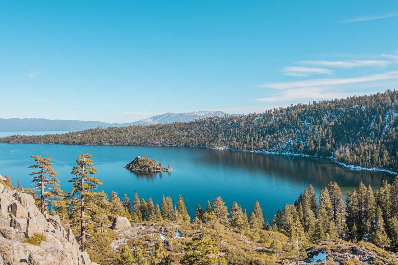
Emerald Bay
Emerald Bay State Park is designated as an underwater state park–if you looked beneath the surface of the bay you would find wrecked boats from the early days of this state park and its Emerald Bay Resort. Besides visiting the famous Vikingsholm, you can find several breathtaking hikes around the Emerald Bay.
Eagle Lake Trail
If you’re looking for a hike with stunning views of Emerald Bay, this 2-mile out & back hike gives you several great viewpoints of the Bay on the way to Eagle Lake. Make sure to get to the Eagle Falls Trailhead early, this is a very popular trail for the area.
Cascade Falls Trail
Cascade Falls Trail heads south from the Southern end of Emerald Bay and provides a moderate hike with views of Lake Tahoe, Desolation Wilderness, Cascade Lake, and finally Cascade Falls. At 1.4 miles, it’s a relatively short but beautiful hike. It’s best to visit in the Spring when the waterfalls are at their strongest!
You can find the trailhead for Cascade Falls Trail off Highway 89, behind the Bayview Campground. The parking lot may fill up here, so plan to get there early!
No matter where you choose to hike when you visit Lake Tahoe, AvantStay has a collection of 60+ houses around Lake Tahoe where you can experience an upscale hospitality experience with a home-like feel. Browse our locations in Lake Tahoe to find your perfect vacation spot.